Sunday March 1, 2009
Granite Creek Trail
It was another amazingly beautiful day in Juneau. Barely a cloud in the sky for the City everyone was telling me has among the worst weather in Alaska. My goal today was to get as far up Mount Juneau as possible.
I started up Perseverance Trail at around 1:30pm. The trail head is located at the end of Basin Road right behind downtown Juneau. It is only a 12 minute walk from where I work.
It is a popular trail with locals and a good trail had been established in the snow with a cross country ski trail next to it for most of the way. The trail starts off following an access road for Juneau's main water supply and an abandoned gold mine now turned into a museum for a quarter mile. The trail then hangs a right and climbs up, skirting around the mountain with steep cliffs on right, and a sheer rock face on the left. Many small snow slides crossed the trail making the footing very precarious. A slip in here would take a person hundreds of feet down to the valley bottom.

As the trail curves around the mountain a nice set of falls emerge down below. With the falls, more of the valley is revealed behind. After hiking 30 minutes, I reach the beginning of the Mount Juneau trail veering off to the left. Even though the sign pointed to the left and the main trail I was on was well packed down, I saw only the faint tracks of one person attempting to go up the trail. I tried following the faint tracks for 10 minutes straight up a snowslide but thought better. If it slid once it can slide again, especially since I almost got caught in an avalanche near Anchorage the winter before.
So instead of risking the hike up the mount Juneau trail I continued on to what turns into the Granite Creek trail. This trail winds up as far as the valley goes ,judging from the map I had, and dead ends in front of steep mountains on all sides just short of the massive Juneau Ice Field. I was eager to get as close to it as possible.
A short distance later, I ran into 3 back country skiers and one snowboarder who were coming back from Sheep Mountain. They did it as a loop trip starting up the Mount Roberts trail, skiing down Sheep Mountain and hiking back out this trail. They said the snow was wind blown and hard in spots.
Granite Creek Trail
It was another amazingly beautiful day in Juneau. Barely a cloud in the sky for the City everyone was telling me has among the worst weather in Alaska. My goal today was to get as far up Mount Juneau as possible.
I started up Perseverance Trail at around 1:30pm. The trail head is located at the end of Basin Road right behind downtown Juneau. It is only a 12 minute walk from where I work.
It is a popular trail with locals and a good trail had been established in the snow with a cross country ski trail next to it for most of the way. The trail starts off following an access road for Juneau's main water supply and an abandoned gold mine now turned into a museum for a quarter mile. The trail then hangs a right and climbs up, skirting around the mountain with steep cliffs on right, and a sheer rock face on the left. Many small snow slides crossed the trail making the footing very precarious. A slip in here would take a person hundreds of feet down to the valley bottom.
As the trail curves around the mountain a nice set of falls emerge down below. With the falls, more of the valley is revealed behind. After hiking 30 minutes, I reach the beginning of the Mount Juneau trail veering off to the left. Even though the sign pointed to the left and the main trail I was on was well packed down, I saw only the faint tracks of one person attempting to go up the trail. I tried following the faint tracks for 10 minutes straight up a snowslide but thought better. If it slid once it can slide again, especially since I almost got caught in an avalanche near Anchorage the winter before.
So instead of risking the hike up the mount Juneau trail I continued on to what turns into the Granite Creek trail. This trail winds up as far as the valley goes ,judging from the map I had, and dead ends in front of steep mountains on all sides just short of the massive Juneau Ice Field. I was eager to get as close to it as possible.
A short distance later, I ran into 3 back country skiers and one snowboarder who were coming back from Sheep Mountain. They did it as a loop trip starting up the Mount Roberts trail, skiing down Sheep Mountain and hiking back out this trail. They said the snow was wind blown and hard in spots.
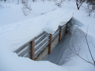
The trail led to a look-out shelter where I stopped and had a snack. From there, the trail continued winding down the valley and the snow kept getting deeper. The nicely packed down trail from the start of the hike was now just a cross-country ski trial. The snow was so deep in parts it covered up an entire bridge with four-foot railings easily.
The trail eventually disapeared completely and I was lucky to find wind blown snow drifts that were solid enough for good hiking. My stopping point was at the valley's end next to some old mining ruins. It was a very beautiful spot. I imagined going over the high mountain pass onto the Juneau Icefield. I was however already sore from yesterday's hike and decided to head back now while their was still daylight.
On the way back I say a huge porcupine. It scampered up a tree and startled me as I walked pass. I was only able to get a picture with the animal behind the branches of the trees.

Even though I heard this trail was muddy in the summer, it is a place I would love to spend some more time exploring.


